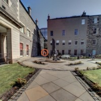
360 Tour Gallery
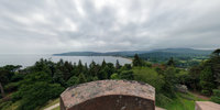
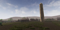
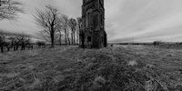
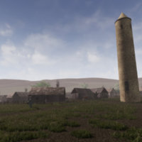
Abernethy
Abernethy Tay Landscape Partnership
Abernethy Wee Big Dig (Tay Landscape Partnership)
An Crùbh
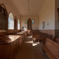
Arbroath Mortuary Church
Armadale
Armadale Castle Museum
Aros Centre
Balvenie Distillery
Barpa Nam Feannag
Barr Castle
Barry Mill, Carnoustie, Scotland
Bell Pettigrew Museum
Ben Lomond
Benholm Church, Scotland
Bennachie 1860
Bennachie Boundary Marker
Blair Castle

Boddin Point
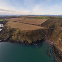
Boddin Point
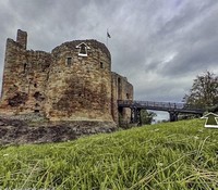
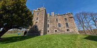
Brodick Castle
Brodick Castle

Burghead Visitor Centre Tour
Caen
Caen Township
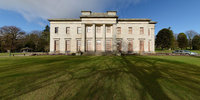
Camperdown House
Camuscross
Caravat Barp
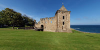
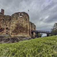
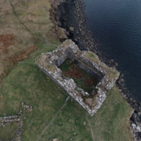
Castle Stalker
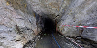
Cononish Mine
Cottown Clay Houses of the Carse
Covesea Lighthouse Tour
Cowgate

Crammond
Cramond Kirk
Crarae Garden

Crarae Garden (National Trust for Scotland)
Crathes Castle
Culloden Battlefield
Culzean Castle
Culzean Castle
David Welch Winter Gardens

David Welch Winter Gardens

David Welch Winter Gardens

David Welch Winter Gardens
Dean Castle

Dirleton Castle
Dirleton castle
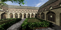
Drum Castle
Dun An Sticir
Dunscaith Castle
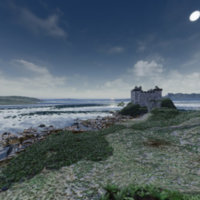
Dunscaith Castle Reconstruction
Ecclesgreig Castle

Ecclesgreig Castle
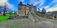
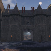
Edinburgh castle

Edzell Castle
Edzell Castle
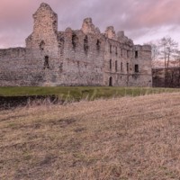
Elcho Castle, Scotland

Falkland Palace and Garden
Falkland Palace and Garden
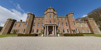
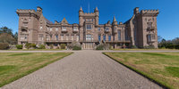
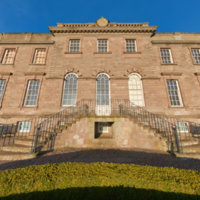
Fasque House

Fasque House

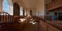
Fetteresso Church
Fetteresso Church

Fort George
Giant MacAskill Memorial
Gladstone's Land
Gladstone's Land
Glamis Castle
Glamis Castle
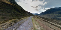
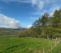
Glencoe
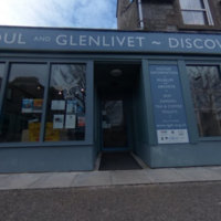
Glenlivet
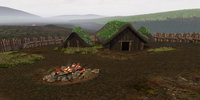
Glenshee Archaeology Project Reconstruction
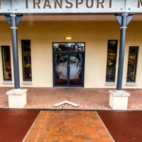
Grampian Transport Museum

Grangemouth Harbour
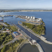
Grangemouth Harbour
Grassmarket
Helmsdale
Holy Trinity 1559
Holyrood Palace
Holyroodhouse Palace

Holyroodhouse Palace

Hope Paton Bowling Green
Hope Paton Bowling Green
House of Dun
Hugh's Castle
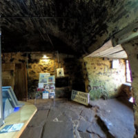
Illicit Still Experience
Inglis Memorial Hall

Inglis Memorial Hall
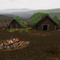
Iron Age Roundhouse
Isle Martin
Isle Ornsay Harbour
Kelvingrove Museum
Kennetpans Distillery

Kennetpans Distillery

King James Library
King James Library University of St Andrews
King's Theatre

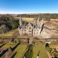
Kinnaird Castle
Kinnaird Castle

Kinneff Old Church
Kinneff Old Church
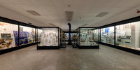
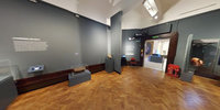
Kirkcaldy Museum and Art Gallery virtual tour
Kirkcaldy Old Kirk
Langass
Leacach An Tigh Chloiche, North Uist
Longhouse Farming Settlement
Lord of the Isles - 15th Century Finlaggan
MUSA
McManus Gallery, Dundee, Scotland
Moncreiffe Hill Fort Tay Landscape Partnerhip

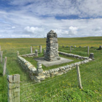
Montrose War Memorial
Montrose War Memorial
Museum of Abernethy

Netherbow Port
Netherbow Port
Newhaven and Western Harbour
Paisley Abbey
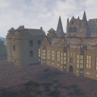
Perth 1440
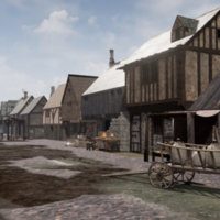
Perth 1440
Perth Museum
Pictish Rhynie Landscape

Port of Leith
Port of Leith
Portencross Castle
Raemoir House
Rockcliffe (National Trust for Scotland)
Rosemarkie
Rosslyn Chapel
Rowallan Castle
Scapa Flow
Scone Abbey
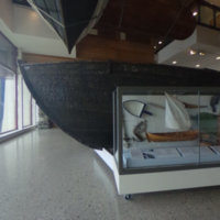
Shetland Museum Boat Hall
St Andrews 1559
St Andrews Castle
St Andrews Cathedral
St Andrews Preservation Trust
St Andrews University - School of Classics
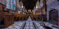
St Giles Kirk
St Maurs, Glencairn Parish Church
St Palladius Church

St Palladius Church
St Salvator's Chapel
Stac Pollaidh

Sunnyside Royal Hospital
Sunnyside Royal Hospital
Surgeons' Hall Museums Virtual Tour
Taigh Chearsabhagh
Taigh Chearsabhagh Museum and Arts Centre
Tentsmuir Forest and Beach
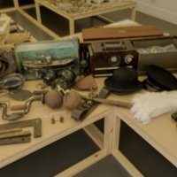
The Devils Porridge WW Gallery
The Gordon Highlanders Museum 360 Virtual Tour - Aerial
The Highlanders Museum
The Hill House

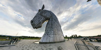
The Kelpies
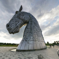
The Kelpies
TimeSpan Museum
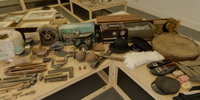
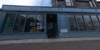
Tomintoul History
Torridon
Trinity College
Udal

Unival
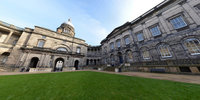
University of Edinburgh

Univirsity of Dundee
Urquhart Castle
Virtual Medieval Abernethy 1070AD
Virtual Moredun Top Hillfort 50AD
Virtual St Kilda 1890
Virtual tours of MV Spartan and SY Carola
Wallace's Monument, Ayrshire

Wallace's Monument, Ayrshire
West Bow
Abernethy
Abernethy
Description: A village in Perth and Kinross, Abernethy is home to one of Scotland's two surviving Irish-style round towers.
Abernethy Tay Landscape Partnership
Abernethy Tay Landscape Partnership
Description: Abernethy is a village in Perth and Kinross, Scotland, situated 8 mi south-east of Perth
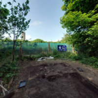
Abernethy Wee Big Dig (Tay Landscape Partnership)
Abernethy Wee Big Dig (Tay Landscape Partnership)
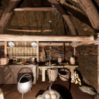
An Crùbh
An Crùbh
Description: Three things were at the top of the community’s wish list – a shop, a proper hall for activities, and a place to meet and socialise. Thus, the idea for An Crùbh was born. The journey to build An Crùbh began in 2011. We received generous support from The Big Lottery Fund, The Coastal Communities Fund, Highland Council, The Robertson Trust, HIE, Fearann Eilean Iarmain, Camuscross & Duisdale Initiative Fundraising Group and architects WT Architecture. The Common Grazings Shareholders were also very generous in their support of the project.
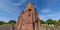
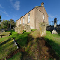
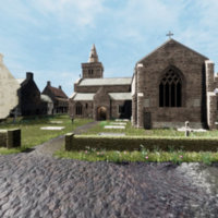
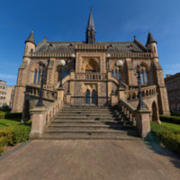
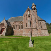
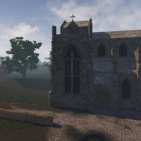
Arbroath Mortuary Church
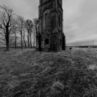
Arbroath Mortuary Church
Description: The Mortuary Chapel was built in 1884 by Patrick Allan-Fraser as a mausoleum for the Fraser family. The building was later gifted to the people of Arbroath as a non-denominational chapel, with maintenance of the chapel falling to the Patrick Allan-Fraser of Hospitalfield Trust. The chapel is built in red sandstone with intricate carvings embellish the interior and exterior. The tour is a 360º photograph of the outside of the building, showing the structure and the surrounding cemetery. The view is just to the side of the main entrance. Accessibility note: There is a small step to enter the chapel. No disabled access to the upper floor. Parking is very limited around the monument.
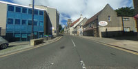
Armadale
Armadale
Description: Armadale (Scottish Gaelic: Armadal) is a village near the southern end of the Sleat Peninsula, on the Isle of Skye, Scotland, and is a village in the Highland council area of Scotland.
Armadale Castle Museum
Armadale Castle Museum
Aros Centre
Aros Centre
Description: Aros is a popular visitor attraction and community cultural centre offering exhibitions, cinema, live music, comedy, dance, drama, theatre, galleries and workshops. With a family friendly restaurant, gift shop and children’s play areas.
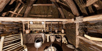
Balvenie Distillery
Balvenie Distillery
Description: Balvenie is a Speyside single-malt distillery which was founded in 1886 by William Grant. The first distillation took place on 1 May 1893. Balvenie is one of the only distilleries in Scotland with its own malting floor. The distillery is located near the ruined Balvenie Castle, which was built in the twelfth century with extension made in the fifteenth and sixteenth centuries. The tour consists of seven 360º images taken from different spots around the distillery ground. The image are located in the bottom left corner. Accessibility note: There is no wheelchair access to the building. On tours walking is required and there are steps.
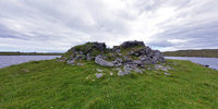
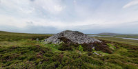
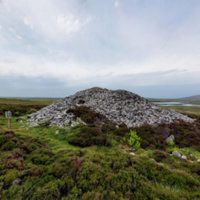
Barpa Nam Feannag
Barpa Nam Feannag
Description: Barpa nam Feannag, ominously called ‘Cairn of the Hooded Crows’ in English, is both less accessible and less well known than Barpa Langass. Erskine Beveridge described it as ‘a long irregular mound of loose stones, lying approximately east and west’. He noted that this barp was higher and wider at the east end, suggesting that there may have once been a chamber there with a ‘large flat stone at the exterior base’ and a large rectangular opening presenting a sign of a possible entrance passage. He also recorded that the surface of the ground was excessively ‘pitted by many slight hollows’. The regularity, size and shape of these hollows suggests the original Neolithic structure, although he noted that none of the ‘upright boundary slabs’ so characteristic of such cairns remained.
Barr Castle
Barr Castle
Description: More information - http://www.barrcastle.co.uk
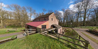
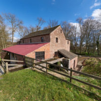
Barry Mill, Carnoustie, Scotland
Barry Mill, Carnoustie, Scotland
Description: Barry Mill is a working Category A listed watermill in Barry, Angus in eastern Scotland. It is owned and operated by the National Trust for Scotland as an educational tourist attraction.
Bell Pettigrew Museum
Bell Pettigrew Museum
Ben Lomond
Ben Lomond
Description: Rising from the east shore of Loch Lomond to a height of 974m (3,193ft), Ben Lomond offers exhilarating walking and spectacular views across Loch Lomond & the Trossachs National Park. The Trust cares for almost 22km2 of land here, including the summits of Ben Lomond, Ptarmigan and Beinn Uird. The mountain is one of Scotland’s most popular hill walks, with over 30,000 people climbing to the summit each year. Ben Lomond is one of the Trust's 46 Munros and is the most southerly Munro in Scotland. Much of Ben Lomond is designated a Site of Special Scientific Interest (SSSI) for the range of upland habitats present from low to high altitude. The property is also tenanted as a sheep and cattle farm, and the Trust and tenant are working together to promote a balance between the grazing use and the needs of natural habitats and wildlife. The area has a rich cultural and archaeological heritage, which you can find out more about through a visit to Ardess Lodge and the Ardess Hidden History Trail.
Benholm Church, Scotland
Benholm Church, Scotland
Description: This site has a long history of religious use. Little is known of the early churches; the first substantial building was erected in the 13th century. The current church is built on a promontory, bordered by a stream; a site typical of early churches. Benholm has had a parish church since at least 1242, but amalgamation of local parishes has resulted in this building now being in Mearns Coastal Parish.
Bennachie 1860
Bennachie 1860
Description: Stories, Stones & Bones This is a digital reconstruction of the 19th-century colonist's buildings, the remains of which are still visible today. Please visit the Bennachie Landscapes Project for more information: http://www.bailiesofbennachie.co.uk/ Heritage Lottery Funded project.
Bennachie Boundary Marker
Bennachie Boundary Marker
Description: The boundary markers seen on the hillside, originate after a Court action was finally settled in 1859, dividing the Commonty of Bennachie between nine local landowners. "Commonty" is land whose ownership is shared among more than one estate. Many people were allowed to take peat and turf from the commonty and to graze livestock there. As the individual boundaries of the landowners were not defined within the commonty, there was a widespread, but legally incorrect belief, that it was common land where anyone could build a house and farm the land. This belief led to the gradual development of the Bennachie Colony. However, the landowners saw this as an intrusion into their legal rights.
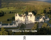
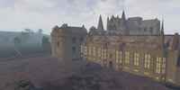
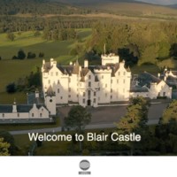
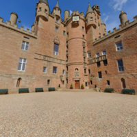
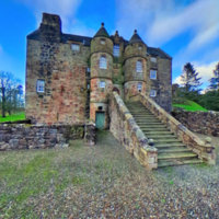
Blair Castle
Blair Castle
Description: Castle dating from 1269 with lavish rooms housing antiques, art and armour, plus walled garden.
Boddin Point
Boddin Point
Description: This tour is a 360º photograph of a section of the Boddin coast, it contains information icons about various points of interest, such as Scurdie Ness Lighthouse and Lunan Bay. Accessibility note: N/A
Boddin Point
Boddin Point
Description: This tour is a 360º photograph of a section of the Boddin coast, it contains information icons about various points of interest, such as Scurdie Ness Lighthouse and Lunan Bay. Accessibility note: N/A
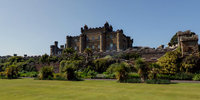
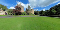
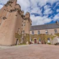
Brodick Castle
Brodick Castle
Description: The quintessential Victorian ‘Highland’ estate, Brodick Castle, Garden & Country Park on the Isle of Arran is the perfect place for a family day out. Dramatically set against the backdrop of Goatfell mountain, the grand red sandstone Scottish baronial-style castle has stunning views over Brodick Bay to the Firth of Clyde. The grounds and surrounds are worthy of a visit alone – from the W A Nesfield-influenced landscaped gardens to the woodland trails, wildlife ponds and waterfalls, there’s plenty to explore outdoors in Britain’s only island country park. Brodick Castle is packed full of treasures too – it’s renowned for its impressive collections of period furniture, silverware, porcelain, paintings and sporting trophies. Remember, Brodick Castle neighbours Goatfell - why not pay both a visit? Brodick Castle and Country Park is unique in being the only island country park in Britain. The castle offers 800 years of history, a fabulous collection of valuable artefacts, and stunning views over Brodick Bay to the Ayrshire coast. The gardens provide an unrivalled experience, from the formal walled garden to the woodland walks. Brodick holds three national collections of rhododendron that flower in almost every month of the year. The country park extends from seashore to mountain top with over ten miles of way-marked trails and abundant wildlife. With its backdrop of mountain peaks, its terraced lawns and luxuriant gardens, Brodick Castle, Garden & Country Park is the very image of a Victorian ‘Highland’ estate.
Brodick Castle
Brodick Castle
Description: 19th-century baronial castle featuring period furniture & art, plus formal gardens & a country park
Burghead Visitor Centre Tour
Burghead Visitor Centre Tour
Caen
Caen
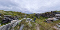
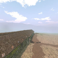
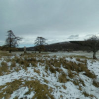
Description: Site of Caen Highland Township, vacated as part of the 19th Century highland clearances
Caen Township
Caen Township
Description: A former highland township. After the highland clearances 200 years ago just a few stones leave evidence of where life had been lived for thousands of years.
Camperdown House
Camperdown House
Description: This 19th century mansion is a category A listed building whose grounds make up Camperdown Park. The park hosts a wildlife centre with close to 200 species of tree across the 400 acre area. It is noteworthy as the origin of the Camperdown Elm, discovered around 1840 by Lord Camperdown’s chief forester. The tour consists of a 360º image of the exterior of one facade of the building and a portion of the grounds. Accessibility note: there is level access to the venue and a wide entry way as well as tarmac paths around the park
Camuscross
Camuscross
Description: Camuscross is a small crofting township on the Isle of Skye in Scotland. Camuscross is situated on Camus Croise bay, on the west shore of the Sound of Sleat, in the Highland Council area. It lies close to the village of Isleornsay and the island of Ornsay.
Caravat Barp
Caravat Barp
Description: Caravat Barp is another example of a ‘Long Cairn’, 165’ overall, with some evidence remaining of a wide ‘horned’ entrance at the East end. Erskine Beveridge noted that it was ‘greatly dilapidated’ at this end, since it had been used as a quarry by local residents for the building of the several shielings and enclosures. Originally this must have been a significant landmark, since the narrower west end in Beveridge’s time stood ‘to a height of 10 feet’.
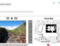
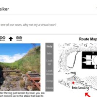
Castle Stalker
Castle Stalker
Description: Built around 1320 for the MacDougalls, the castle today belongs to the Stewarts. Gaelic name is Stalcaire, meaning Hunter or Falconer. The castle was acquired in 1965 by Lt. Col. D. R. Stewart Allward who restored the castle over a period of ten years. The castle is privately owned and is open for visitor during selected times over the summer, to be arranged in advance. Featured in 1975 Monty Python and the Holy Grail as one of the sites for the Castle of Aaaaarrrrrrggghhh. The virtual tour is a set of images you click between, with a blueprint of the castle serving as a point of reference on the right side of the screen. For each movement, a text appears beneath the image with information on the view. For each location, you can look right and left and some will have a pop-up window containing more information. Accessibility note: The castle does not accomodate wheelchair users. Access to the castle requires the ability to enter/exist a boat and there are steps in and around the castle.
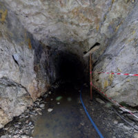
Cononish Mine
Cononish Mine
Cottown Clay Houses of the Carse
Cottown Clay Houses of the Carse
Description: Clay Buildings of the Carse Buildings that were “made out of the ground upon which they stood” were once the most common vernacular structures in parts of Scotland. In the Carse of Gowrie, a substantial number of significant historical structures survive that demonstrate the local tradition of mass clay walls or mud-wall. For more information visit: http://www.taylp.org/historicbuildings/clay-buildings-of-the-carse/
Covesea Lighthouse Tour
Covesea Lighthouse Tour
Cowgate
Cowgate
Description: The Cowgate probably developed as a street in the early fourteenth century. By the sixteenth century it was considered one of the more prosperous parts of Edinburgh. The writer and theologian Alexander Alesius (who was born in Edinburgh in 1500) claimed that Cowgate was where ‘the nobility and chief men of the burgh reside’. In the early sixteenth century the archbishop of St Andrews had a residence there, which survived until Victorian times. In 1537 money was left for the establishment of a hospital and chapel dedicated to Mary Magdalen at the western end of the Cowgate. The Magdalen Chapel still exists today, although the building has been substantially altered
Crammond
Crammond
Description: The small village of Cramond, on the edge of Edinburgh, is one of Scotland’s most important archaeological sites. People have lived in and around Cramond for at least ten thousand years. Today Cramond is a pleasant commuter village for Edinburgh but there remain numerous reminders of its extraordinary past. This website guides you round notable historic sites in Cramond providing brief descriptions, photographs, and in some cases reconstructions of historic locations in the village.
Cramond Kirk
Cramond Kirk
Description: Cramond Kirk is a church situated in the area of Cramond in the north west of Edinburgh, Scotland. Built on the site of an old Roman fort, parts of the Cramond Kirk building date back to the fourteenth century and the church tower is considered to be the oldest part.
Crarae Garden
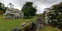
Crarae Garden
Description: Near the banks of Loch Fyne, on the west coast, immerse yourself in Britain's finest example of an exotic Himalayan-style woodland garden. Crarae Garden is a tranquil site, with its dramatic gorge, rippling burn, waterfalls and cliffs. The informal hillside layout of mature woody plants radiating out from the burn creates a wonderful natural effect. It is a magical spot at any time of year, with the earlier flowers of countless rhododendrons, azaleas, camellias and magnolias being replaced later in the season by the rich tints of foliage and fruit.
Crarae Garden (National Trust for Scotland)
Crarae Garden (National Trust for Scotland)
Description: Crarae is one the finest examples of Himalayan-style woodland gardens in Britain. The 50 acre site is situated in an area of outstanding natural beauty on the banks of Loch Fyne in Argyll, Scotland. Crarae Garden was created in 1912 by Lady Grace Campbell, the aunt of intrepid plant hunter Reginald Farrer, who sourced trees and shrubs from China, Nepal and Tibet. The lower garden at Crarae is also home to a neolithic chambered burial cairn.
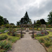
Crathes Castle
Crathes Castle
Description: This 16th century tower house was built by Alexander Burnett and is a maze of turrets and corridors featuring elaborately painted ceilings and wood panelled floors. It sits in a glorious set of gardens amongst the low hills of the area. The inside houses family portraits, antique furniture, and beautiful architecture, while the garden outside is split into 8 sections encompassing an enormous host of plants. The tour here consists of two 360º images, one exterior of the house and then one in the center of one of the garden’s areas to give a taste of the rest to come. Accessibility note: There is accessible parking and the site is wheelchair accessible, there is also a bike route and a self-guided, dog friendly, trail.
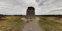
Culloden Battlefield
Culloden Battlefield
Description: THE BATTLE OF CULLODEN was fought on this moor 16 April 1746 The Graves of the Gallant Highlanders who fought for SCOTLAND AND BONNIE PRINCE CHARLIE are marked by the names of their clans
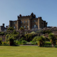
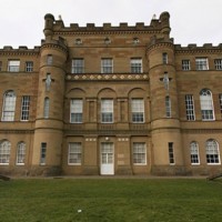
Culzean Castle
Culzean Castle
Description: Designed by Robert Adam in the 18th century, this opulent castle sits atop the Ayrshire cliffs as one of 40 buildings in the 260 ha estate of the 10th Earl of Cassillis. The estate features a Swan Pond, an ice house, formal gardens, and an indoor fruit garden, as well as the famous Oval Staircase at the centre of the castle, also an Adam design. There is a self-guided trail through the grounds which visitors can take as well as guided tours, picnic areas, and wheelchair access There is a 360º image of the staircase, linked blow, as well as a set of external 360º images in and around the castle grounds, above. Accessibility note: There is accessible parking and dogs are allowed https://roundme.com/tour/52578/view/133164/
Culzean Castle
Culzean Castle
Description: Designed by Robert Adam in the 18th century, this opulent castle sits atop the Ayrshire cliffs as one of 40 buildings in the 260 ha estate of the 10th Earl of Cassillis. The estate features a Swan Pond, an ice house, formal gardens, and an indoor fruit garden, as well as the famous Oval Staircase at the centre of the castle, also an Adam design. There is a self-guided trail through the grounds which visitors can take as well as guided tours, picnic areas, and wheelchair access There is a 360º image of the staircase, linked blow, as well as a set of external 360º images in and around the castle grounds, above. Accessibility note: There is accessible parking and dogs are allowed https://roundme.com/tour/52578/view/133164/
David Welch Winter Gardens
David Welch Winter Gardens
Description: One of Britain’s largest indoor gardens, the David Welch Winter Gardens boasts the most extensive collection of succulents and cacti in Europe. It includes a Temperate House, a Corridor of Perfumes, a Fern Houses, a Victorian Corridor, a Japanese Garden, A Tropical House, and an Arid House. Originally opened in 1899, the greenhouses were rebuilt after suffering storm damage in 1969. Located next to Duthie Park, the tour starts in the park and moves through the indoor gardens with a set of interactive 360º photos that allow easy travel through the spaces. Accessibility note: The ground in the gardens varies but the majority is level paving with wide doorways.
David Welch Winter Gardens
David Welch Winter Gardens
Description: One of Britain's largest indoor gardens, the David Welch Winter Gardens boasts the most extensive collection of succulents and cacti in Europe. It includes a Temperate House, a Corridor of Perfumes, a Fern Houses, a Victorian Corridor, a Japanese Garden, A Tropical House, and an Arid House. Originally opened in 1899, the greenhouses were rebuilt after suffering storm damage in 1969. Located next to Duthie Park, the tour starts in the park and moves through the indoor gardens with a set of interactive 360º photos that allow easy travel through the spaces. Accessibility note: The ground in the gardens varies but the majority is level paving with wide doorways.
David Welch Winter Gardens
David Welch Winter Gardens
Description: One of Britain's largest indoor gardens, the David Welch Winter Gardens boasts the most extensive collection of succulents and cacti in Europe. It includes a Temperate House, a Corridor of Perfumes, a Fern Houses, a Victorian Corridor, a Japanese Garden, A Tropical House, and an Arid House. Originally opened in 1899, the greenhouses were rebuilt after suffering storm damage in 1969. Located next to Duthie Park, the tour starts in the park and moves through the indoor gardens with a set of interactive 360º photos that allow easy travel through the spaces. Accessibility note: The ground in the gardens varies but the majority is level paving with wide doorways.
Dean Castle
Dean Castle
Description: Dean Castle Country Park
Dirleton Castle
Dirleton Castle
Description: The castle’s construction began in 1240 but was damaged in the Wars of Scottish Independence. The castle guarded the approach along the coast to Edinburgh from the south. It changed hands multiple times throughout its history, and was damaged again in a siege by Oliver Cromwell, in 1923 the grounds and ruins were given to state care and they are now maintained by Historic Scotland. The current site is made up of 13th, 14th, 15th, and 16th century ruins as well as a 20th century garden layout. The tour consists of a number of navigable 360º photographs that take the viewer around the ruins of the castle. Accessibility note: The ground around the castle is uneven and there is stepped access into the ruins themselves.
Dirleton castle
Dirleton castle
Description: The Camera New on the market in July 2017, the Garmin Virb360 camera is an extremely capable 360° device. The images in this tour were captured as bracketed exposures, blended together in Adobe Lightroom and processed using the KRPano Virtual Tour software. All images were captured initially in jpg format but recent firmware upgrades to the camera now allow for capture of images in RAW format with a consequential improvement of both dynamic range and tonal quality.
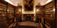
Drum Castle
Drum Castle
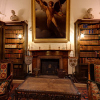
Description: Take in an enormous sweep of Scottish history as experienced by the Irvine family who lived in Drum Castle for over 650 years, from the 14th century onwards. Drum is one of Royal Deeside’s top historic attractions, just 10 miles from Aberdeen. It is one of Scotland’s oldest tower houses and is set beside an ancient oak woodland and a walled garden that contains a fine collection of historic roses which perfume the air. William de Irwyn was gifted the Royal Forest of Drum and the Tower of Drum by King Robert the Bruce in 1323. The tower has benefitted from various improvements over the centuries, including a Jacobean mansion house extension in 1619 and Victorian adaptations, such as the impressive library converted from the lower hall
Dun An Sticir
Dun An Sticir
Description: Dun an Sticir is an example of how in mediaeval times the original Iron Age 'brochs', hollow walled windowless fortifications often built on islands and reached by a tricky causeway, were later adapted for more domestic purposes. The building of brochs for defensive purposes seems to date from 500 BC. Over the previous thousand years cooler climactic changes had encouraged layers of peat to gradually move downhill, overgrazing had taken its toll, and land for cultivation had become scarcer, forcing people to migrate to the lower ground. Duns comprised a single outer rounded wall, forming a tall tower often rising to 40 feet, mirrored internally by a second curving wall enclosing an inner chamber. This was a relatively straightforward fortification to build in order to protect your land. Erskine Beveridge also found evidence at Dun an Sticir of a gallery six feet above ground level. Remains of two huts where livestock could have been protected could also be seen. The rectangular stone structure built within the walls using the stone available, with its door and window, dates from the mediaeval period. A second island, Eilean na Mi-Chomhairle (the Island of Bad Council), is linked to Dun an Sticir (the Dun of the Skulker) by a causeway. Both Gaelic names suggest a darker and less peaceful era.
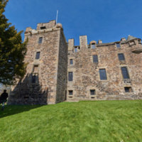
Dunscaith Castle
Dunscaith Castle
Description: Dunscaith, Skye's oldest castle is situated north of Tarskavaig by the township of Tokavaig. It was a Norse stronghold, and then a MacLeod castle until taken by MacDonald's in 1266. It was the principle stronghold of the MacDonald's of Sleat until the early 1600's.
Dunscaith Castle Reconstruction
Dunscaith Castle Reconstruction
Description: Dunscaith, Skye's oldest castle is situated north of Tarskavaig by the township of Tokavaig. It was a Norse stronghold, and then a MacLeod castle until taken by MacDonald's in 1266. It was the principle stronghold of the MacDonald's of Sleat until the early 1600's.
Ecclesgreig Castle
Ecclesgreig Castle
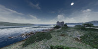
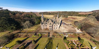
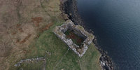
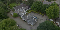
Description: Built in 1844 from the remains of St Cyrus House, Ecclesgreig Castle stood at the centre of an agricultural estate. Now no longer a functioning house, the castle still commands impressive views of the sea nearby and hosts an Italian renaissance style garden with a 140 ft long herbaceous border, Neoclassical sculptures, and masterful topiary. The striking castle famously inspired Bram Stoker's Dracula after the writer spent some time there. It hosts a 'snowdrop walk' through its grounds where over 150 variations of the small flower grow bountifully. The image is an ariel 360º photo of the garden and castle. Accessibility note: The garden and snowdrop walk do not accommodate wheelchair usage
Ecclesgreig Castle
Ecclesgreig Castle
Description: Built in 1844 from the remains of St Cyrus House, Ecclesgreig Castle stood at the centre of an agricultural estate. Now no longer a functioning house, the castle still commands impressive views of the sea nearby and hosts an Italian renaissance style garden with a 140 ft long herbaceous border, Neoclassical sculptures, and masterful topiary. The striking castle famously inspired Bram Stoker’s Dracula after the writer spent some time there. It hosts a ‘snowdrop walk’ through its grounds where over 150 variations of the small flower grow bountifully. The image is an ariel 360º photo of the garden and castle. Accessibility note: The garden and snowdrop walk do not accommodate wheelchair usage
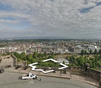
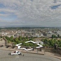
Edinburgh castle
Edinburgh castle
Description: Since the 12th century and the reign of David I, there has been a royal castle on the rock overlooking the area that is now Edinburgh, but the site has been occupied since the Bronze Age. It has been the location of many conflicts throughout its history, playing key roles in the Wars of Scottish Independence and the Jacobite rebellion. Today, the castle is one of Scotland’s most visited tourist attractions, with over two million visitors in 2017. It plays host to many events, notably including the Military Tattoo during the annual Edinburgh Festival in the summertime. Above is a 360º drone video, but the link provides a more in depth look at the fortress. This tour is a Google-powered set of 360º photographs that allow the viewer to navigate the fortress and and ‘walk’ through it. Accessibility note: All areas of the castle are accessed from a 350m long, sloped route. This route is cobbled and so can be a steep, uneven surface. There are stairs to some areas of the castle, but many have ramp access - such as the Great Hall, the National War Museum, and St Margaret’s Chapel.
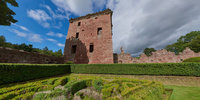
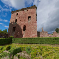
Edzell Castle
Edzell Castle
Description: The castle was built in 1520 with walled gardens from the 17th century. The castle is today a ruin but the garden is still maintained. The castle was built by the 8th Earl of Crawford and the garden expanded in 1604 by his son. Today the castle belongs to Historic Scotland and is open all year. The castle once housed Mary Queen of Scots on a visit in 1562. was occupied by English troops during Oliver Cromwell's invasion of Scotland in 1651. The grounds further contain a family burial vault and a summer house which can be explored. Tour is a 360º view from the 17th century formal garden with a close view of the castle ruins and the wall. Accessibility note: The castle has partial wheelchair access. There are ramps leading to the visitor centre and all part of the garden are accessible. The castle itself has step and cobble surfaces and is not suitable for users with physical disabilities.
Edzell Castle
Edzell Castle
Description: The castle was built in 1520 with walled gardens from the 17th century. The castle is today a ruin but the garden is still maintained. The castle was built by the 8th Earl of Crawford and the garden expanded in 1604 by his son. Today the castle belongs to Historic Scotland and is open all year. The castle once housed Mary Queen of Scots on a visit in 1562. was occupied by English troops during Oliver Cromwell's invasion of Scotland in 1651. The grounds further contain a family burial vault and a summer house which can be explored. Tour is a 360º view from the 17th century formal garden with a close view of the castle ruins and the wall. Accessibility note: The castle has partial wheelchair access. There are ramps leading to the visitor centre and all part of the garden are accessible. The castle itself has step and cobble surfaces and is not suitable for users with physical disabilities.
Elcho Castle, Scotland
Elcho Castle, Scotland
Description: Elcho Castle is located a short distance above the south bank of the River Tay approximately four miles south-east of Perth, Scotland. It consists of a Z-plan tower house, with fragments of a surrounding wall with corner towers.
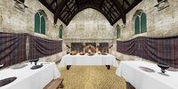
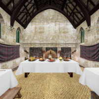
Falkland Palace and Garden
Falkland Palace and Garden
Description: King James IV and his son, James V, commissioned this palace in the early 16th century. The Kings loved hunting and falconry, and this was created as a sort of holiday house for them to pursue these hobbies. There are many fairytale-esque buildings to explore, including the Chapel Royal and Britain's oldest real tennis court. The surrounding gardens are home to an orchard and wildflower meadow as well as a Renaissance style herbal garden. This tour consists of a set of multiple 360º photographs from both inside and out of the palace allowing the viewer to experience much of what is on offer. Accessibility note: This is unsuitable for wheelchairs as there are a lot of stairs. There is a hearing loop and large print guides.
Falkland Palace and Garden
Falkland Palace and Garden
Description: King James IV and his son, James V, commissioned this palace in the early 16th century. The Kings loved hunting and falconry, and this was created as a sort of holiday house for them to pursue these hobbies. There are many fairytale-esque buildings to explore, including the Chapel Royal and Britain's oldest real tennis court. The surrounding gardens are home to an orchard and wildflower meadow as well as a Renaissance style herbal garden. This tour consists of a set of multiple 360º photographs from both inside and out of the palace allowing the viewer to experience much of what is on offer. Accessibility note: This is unsuitable for wheelchairs as there are a lot of stairs. There is a hearing loop and large print guides.
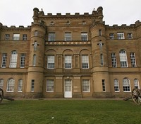
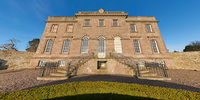
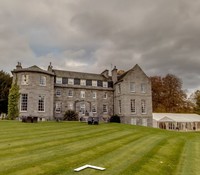
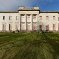
Fasque House
Fasque House
Description: The present house was completed in 1809 to replace an earlier house which had been demolished due to damp damage. In 1829, the house was bought by Sir John Gladstone, the father of later Prime Minister William Ewart Gladstone. The house is surrounded by beech avenues originally planted in the 1750s. Fasque House was possibly the first house in Scotland to have electric lighting and had an electric buzzer system installed in 1890. The House can today be rented out for weddings and events. The tour is a 360º view of the front and gardens of the House. Accessibility note: The House has a few areas that are not suitable for disabled access, but the House has a lift to the main function and bedroom floor and some bedrooms allow disabled access and walk-in shower.
Fasque House
Fasque House
Description: The present house was completed in 1809 to replace an earlier house which had been demolished due to damp damage. In 1829, the house was bought by Sir John Gladstone, the father of later Prime Minister William Ewart Gladstone. The house is surrounded by beech avenues originally planted in the 1750s. Fasque House was possibly the first house in Scotland to have electric lighting and had an electric buzzer system installed in 1890. The House can today be rented out for weddings and events. The tour is a 360º view of the front and gardens of the House. Accessibility note: The House has a few areas that are not suitable for disabled access, but the House has a lift to the main function and bedroom floor and some bedrooms allow disabled access and walk-in shower.
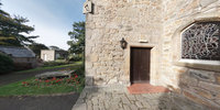
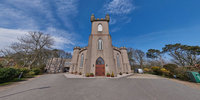
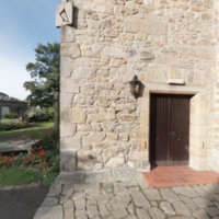
Fetteresso Church
Fetteresso Church
Description: A church of St. Kieran, Fetteresso Church was dedicated Roman Catholic in 1246 before changing to Protestant under Mary Queen of Scots in the 1560s. It is currently a functioning part of the Church of Scotland and the frontage of the building was modelled from Fetteresso Castle. The image is a 360º photo outside the front of the church showing the promenade leading up to it. Accessibility note: The ground is flat and there are no stairs up to the building, but there is not currently information on the interior available
Fetteresso Church
Fetteresso Church
Description: A church of St. Kieran, Fetteresso Church was dedicated Roman Catholic in 1246 before changing to Protestant under Mary Queen of Scots in the 1560s. It is currently a functioning part of the Church of Scotland and the frontage of the building was modelled from Fetteresso Castle. The image is a 360º photo outside the front of the church showing the promenade leading up to it. Accessibility note: The ground is flat and there are no stairs up to the building, but there is not currently information on the interior available
Fort George
Fort George
Description: 18th-century fortified garrison and working army barracks, housing Highlanders' regimental museum.
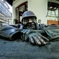
Giant MacAskill Memorial
Giant MacAskill Memorial
Description: At the southern end of the island you will find a monument to one of Berneray’s most notable sons, Giant Macaskill (Aonghas Mor MacAsgaill). Born in Berneray, he spent most of his life in Cape Breton, Nova Scotia, and he was said to be the world largest giant at a height of 7ft 9in.
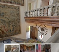
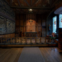
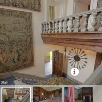
Gladstone's Land
Gladstone's Land
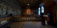
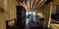
Description: Gladstone’s Land is the restored 17th century home of wealthy merchant and landlord Thomas Gledstanes. Gledstanes let out rooms in this six-storey building and the restored rooms reflect how these people from different social spheres went about their day in Edinburgh’s Lawnmarket area. The museum is on the first and second floors of the house split across six rooms. The museum only offers guided tours. The tour consists of six views of four different rooms on one of the floors of the museum. The images are 360º degrees and you can click between the rooms via points that guide you through the house. Accessibility note: Unknown, but the museum levels of the house are connected via a staircase.
Gladstone's Land
Gladstone's Land
Description: Gladstone's Land is the restored 17th century home of wealthy merchant and landlord Thomas Gledstanes. Gledstanes let out rooms in this six-storey building and the restored rooms reflect how these people from different social spheres went about their day in Edinburgh's Lawnmarket area. The museum is on the first and second floors of the house split across six rooms. The museum only offers guided tours. The tour consists of six views of four different rooms on one of the floors of the museum. The images are 360º degrees and you can click between the rooms via points that guide you through the house. Accessibility note: Unknown, but the museum levels of the house are connected via a staircase.
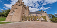
Glamis Castle
Glamis Castle
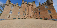
Description: Glamis Castle was the childhood home to HM Queen Elizabeth and the Queen Mother, having been the ancestral seat of the Earls of Strathmore and Kinghorne since 1372. The site’s history dates back to 1034 when King Malcolm II was murdered there at a Royal Hunting Lodge. The tour a 360º photograph of the Castle’s courtyard which looks out into the grounds and down a section of the long driveway. Accessibility note: The ground floor, including the restaurant, is wheelchair accessible, but the castle tour includes uneven floor and stairs throughout. Motorised scooters are available for free to access the gardens.
Glamis Castle
Glamis Castle
Description: Glamis Castle was the childhood home to HM Queen Elizabeth and the Queen Mother, having been the ancestral seat of the Earls of Strathmore and Kinghorne since 1372. The site's history dates back to 1034 when King Malcolm II was murdered there at a Royal Hunting Lodge. The tour a 360º photograph of the Castle's courtyard which looks out into the grounds and down a section of the long driveway. Accessibility note: The ground floor, including the restaurant, is wheelchair accessible, but the castle tour includes uneven floor and stairs throughout. Motorised scooters are available for free to access the gardens.
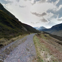
Glencoe
Glencoe
Description: The most famous Scottish glen is also one of its most dramatic, with forbidding mountains, thundering waterfalls and sparkling lochs. Internationally famous for its amazing landscape, its natural and cultural heritage; the scenery of Glencoe has been fashioned by millions of years of geological and geomorphologic processes is now regarded as some of the finest ‘wild’ landscape in Scotland. The drama is also reflected in Glencoe’s history, both real and imagined – myths, massacre and movies are all now part of the fabric of this magical, mysterious place. Walkers and climbers are drawn from all over the world to tackle its many mountaineering routes, including eight Munros, while animal-lovers come to catch a glimpse of Scottish wildlife including red deer, golden eagles and pine martens.
Glenlivet
Glenlivet
Description: Glenlivet is the glen in the Scottish Highlands through which the River Livet flows.
Glenshee Archaeology Project Reconstruction
Glenshee Archaeology Project Reconstruction
Description: Digital reconstruction of Pictish Buildings at Lair, Glenshee. Created in Unreal Engine.
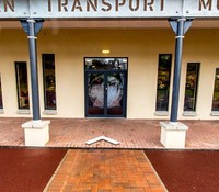
Grampian Transport Museum
Grampian Transport Museum
Description: Set just 45 minutes away from Aberdeen, in the village of Alford, the Grampian Transport Museum has an extensive collection of vehicles from across history. Since its foundation in the 1980s, the museum has hosted many events and transport related activities for the public to go to in the summer months. It is updated every year to ensure the newest and most exciting items are on display each season. The tour is a Google powered interactive set of 360º photos that show the entrance and first areas of the museum Accessibility note: The museum is 100% wheelchair accessible as well as being dog friendly
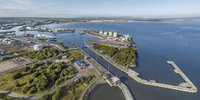
Grangemouth Harbour
Grangemouth Harbour
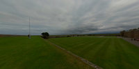
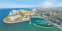
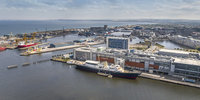
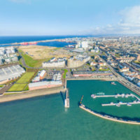
Description: The Port of Grangemouth is Scotland's largest container port and is linked via motorway, rail, and sea. The port handles approximately 150,000 containers per year and up to 30% of Scotland's gross domestic product (GDP) goes through the port. It is only feeder port in the UK that exports more than it imports. The tour consists of five 360º images of the areas with information boxes inserted over noteworthy elements. Accessibility notes: N/A.
Grangemouth Harbour
Grangemouth Harbour
Description: The Port of Grangemouth is Scotland’s largest container port and is linked via motorway, rail, and sea. The port handles approximately 150,000 containers per year and up to 30% of Scotland’s gross domestic product (GDP) goes through the port. It is only feeder port in the UK that exports more than it imports. The tour consists of five 360º images of the areas with information boxes inserted over noteworthy elements. Accessibility notes: N/A.
Grassmarket
Grassmarket
Description: The Grassmarket area is first recorded in the fourteenth century, when it was referred to as ‘the street called Newbygging under the castle’. By the 1470s the area was known as ‘Westirmart’, and seems to have been associated with the sale of timber, hats, and shoes. At the far end of the Grassmarket stood the gateway known as the West Port, which was in existence by at least 1509, and formed the western boundary of the burgh.
Helmsdale
Helmsdale
Description: Timespan is a cultural organisation in Helmsdale, Sutherland in the Far North of Scotland. It offers a high quality venue with a museum, contemporary art gallery, archive, shop and cafe. Established in 1986, Timespan has developed from a community heritage enterprise to a multi-award-winning creative development hub. Timespan provides a rich cultural programme of events and activities to its visitors every year. The organisation will contribute to CINE with a case study and best practice guidelines based on research of the nearby Strath of Kildonan.
Holy Trinity 1559
Holy Trinity 1559
Description: This tour was funded by St Andrews Community Trust.
Holyrood Palace
Holyrood Palace
Description: The abbey of Holyrood was founded in the twelfth century. During the late Middle Ages the monastery’s guest house gradually evolved into a royal residence. In the early 1500s King James IV ordered the creation of a new palace next to the original religious buildings. His son, James V (the father of Mary Queen of Scots), continued the building work, creating an impressive Renaissance residence. In May 1544 the English sacked both the palace and abbey. The Earl of Hertford, who commanded the English forces, boasted that he left Holyrood Abbey ‘wholly burnt and desolate’.
Holyroodhouse Palace
Holyroodhouse Palace
Description: The Palace of Holyroodhouse is the Queen's official residence in Scotland and contains many artefacts of Scottish royal history. The Queen's Gallery at the Palace of Holyroodhouse hosts a programme of changing exhibitions from the Royal Collection. The Palace was used by Mary, Queen of Scots for official and state entertaining but the Palace as it stands today was built between 1671-78. To access the tour, click the box entitled 'Launch Project' after following the link. The tour is an interactive set of 360º images from three different rooms inside the house. Each room has clickable info boxes that tell facts of the interior decoration. Accessibility note: Pushchair may not be taken into the palace. The lift leading to the State Harbour is under maintenance until April 2019.
Holyroodhouse Palace
Holyroodhouse Palace
Description: The Palace of Holyroodhouse is the Queen’s official residence in Scotland and contains many artefacts of Scottish royal history. The Queen's Gallery at the Palace of Holyroodhouse hosts a programme of changing exhibitions from the Royal Collection. The Palace was used by Mary, Queen of Scots for official and state entertaining but the Palace as it stands today was built between 1671-78. To access the tour, click the box entitled ‘Launch Project’ after following the link. The tour is an interactive set of 360º images from three different rooms inside the house. Each room has clickable info boxes that tell facts of the interior decoration. Accessibility note: Pushchair may not be taken into the palace. The lift leading to the State Harbour is under maintenance until April 2019.
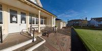
Hope Paton Bowling Green
Hope Paton Bowling Green
Description: Opened in 1904, this bowling green, and gardens, following the generosity of Miss Hope Paton, the daughter of a wealthy merchant who wanted to leave a mark on her hometown. The club has enjoyed a busy history and much local support. This tour is a 360º photograph from the front entrance including the green itself. Accessibility note: The green is viewable from the level but the entrance to the club house is up three steps.
Hope Paton Bowling Green
Hope Paton Bowling Green
Description: Opened in 1904, this bowling green, and gardens, following the generosity of Miss Hope Paton, the daughter of a wealthy merchant who wanted to leave a mark on her hometown. The club has enjoyed a busy history and much local support. This tour is a 360º photograph from the front entrance including the green itself. Accessibility note: The green is viewable from the level but the entrance to the club house is up three steps.
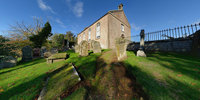
House of Dun
House of Dun
Description: The House of Dun is a National Trust for Scotland property in the parish of Dun, lying close to the edge of Montrose Basin and situated approximatley half way between the towns of Montrose and Brechin, in Angus, Scotland.
Hugh's Castle
Hugh's Castle
Description: How to use: Scroll around each scene using your mouse or by moving your smart phone. Look for interactive links to photos and information about the site. Click on the "portals" to change scene. If using PC or Laptop, double click on the tour window to enter full screen mode. If using a Virtual Reality headset /Google Cardboard or similar then download the RoundMe app for the best viewing experience!
Illicit Still Experience
Illicit Still Experience
Description: Tomintoul is a village in the Moray council area of Scotland; until 1975, it was in the county of Banffshire.
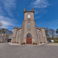
Inglis Memorial Hall
Inglis Memorial Hall
Description: The Memorial Hall and clocktower are built within a public rose garden in the village of Edzell. The Hall and garden are open for various activities such as, drama productions, dance, meetings, and exhibitions. The Library room has been restored from its Victorian state and is now a visitor centre offering a historical insight into the library and community. The tour is a 360º photograph of the front of the building, showing the entryway and clocktower. Accessibility note: There is level parking but the entrance is stepped.
Inglis Memorial Hall
Inglis Memorial Hall
Description: The Memorial Hall and clocktower are built within a public rose garden in the village of Edzell. The Hall and garden are open for various activities such as, drama productions, dance, meetings, and exhibitions. The Library room has been restored from its Victorian state and is now a visitor centre offering a historical insight into the library and community. The tour is a 360º photograph of the front of the building, showing the entryway and clocktower. Accessibility note: There is level parking but the entrance is stepped.
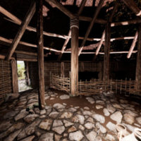
Iron Age Roundhouse
Iron Age Roundhouse
Isle Martin
Isle Martin
Description: Isle Martin (Eilean Mhàrtainn) is an uninhabited island in Loch Broom, on the west coast of Scotland. It is the closest Summer Isles to Ullapool and has been the site of a monastery, a herring curing station and a flour mill.
Isle Ornsay Harbour
Isle Ornsay Harbour
Description: Isleornsay is a village lying off the main Armadale to Sleat road on the Isle of Skye in Scotland. It overlooks, but is not upon, the island of Ornsay. The island itself shelters one of the best natural harbours in southern Skye.
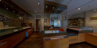
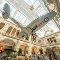
Kelvingrove Museum
Kelvingrove Museum
Description: The gallery opened in 1901 as the Palace of Fine Arts. Built around its large Centre Hall, the museum houses a wide ranging collection of art, arms, and natural history items across 22 galleries. The museum also holds the Salvador Dali painting ‘Christ of St John of the Cross’ from 1951 which shows the crucified Jesus hovering over a dark body of water. The tour consists of a set of 360º images of the interior and exterior of that gallery, showing the suspended Spitfire aircraft. Accessibility note: There is level access and accessible parking and a hearing loop.
Kennetpans Distillery
Kennetpans Distillery
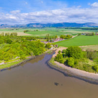
Description: Kennetpans was formed by the monks of Kennetpans Monastery and was a salt panning community. The local farmers learned how to distil from the monastery and in the 1730s it was the largest distillery in Scotland. In the 1770s a second distillery was opened by the brother of the original founder, John Stein. The site is now in ruins, having ceased function in 1825. The tour gives an aerial view of the ruins and the area around them with information points across the landscape. Accessibility note: N/A
Kennetpans Distillery
Kennetpans Distillery
Description: Kennetpans was formed by the monks of Kennetpans Monastery and was a salt panning community. The local farmers learned how to distil from the monastery and in the 1730s it was the largest distillery in Scotland. In the 1770s a second distillery was opened by the brother of the original founder, John Stein. The site is now in ruins, having ceased function in 1825. The tour gives an aerial view of the ruins and the area around them with information points across the landscape. Accessibility note: N/A
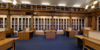
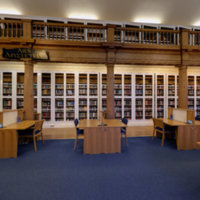
King James Library
King James Library
King James Library University of St Andrews
King James Library University of St Andrews
Description: Founded in 1612 by James VI I, the King James Library is one of the jewels in the University's crown. The building itself was completed in 1643.
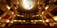
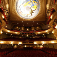
King's Theatre
King's Theatre
Description: Beloved traditional and beautifully preserved, King's Theatre and bar hosts mainstream touring plays, NTS productions, ballet and pantomime. http://www.edtheatres.com/kings#
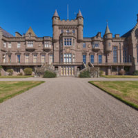
Kinnaird Castle
Kinnaird Castle
Description: The castle has been the property of the Carnegie family since its construction in the early 1400s but early records of the castle's history were lost when the castle burned down in 1452. The estate covers around 7,000 acres of land. The castle was rebuilt in 1791 by the architect James Playfair in the mansion house style and again in 1855 by David Bryce. After a fire 1921, the castle has been continuously rebuilt and adapted to modern conveniences. The castle today rents out apartments for holiday stays. The estate contains multiples spots of scientific interest, especially in its function of wildlife habitat. The castle further has paths laid out for scenic walks across the estate. The tour is a 360º photograph of the front of the castle and the gardens. Accessibility note: Enquire with Castle before stay.
Kinnaird Castle
Kinnaird Castle
Description: The castle has been the property of the Carnegie family since its construction in the early 1400s but early records of the castle’s history were lost when the castle burned down in 1452. The estate covers around 7,000 acres of land. The castle was rebuilt in 1791 by the architect James Playfair in the mansion house style and again in 1855 by David Bryce. After a fire 1921, the castle has been continuously rebuilt and adapted to modern conveniences. The castle today rents out apartments for holiday stays. The estate contains multiples spots of scientific interest, especially in its function of wildlife habitat. The castle further has paths laid out for scenic walks across the estate. The tour is a 360º photograph of the front of the castle and the gardens. Accessibility note: Enquire with Castle before stay.
Kinneff Old Church
Kinneff Old Church
Description: The Parish church of Kinneff was first consecrated in 1242, and has since undergone various alterations and renovations before entering its current state after 1876. It is a typical example of a Scottish ‘T’ shaped kirk which is used to direct the whole congregation to the pulpit. It is open daily for visitors and is a very short drive away from Inverbervie. This tour is a 360 photo of the interior of the kirk, displaying the ‘T’ design and the pared back interior. Accessibility note: There is an accessible parking drop off point as well as both level and ramp access to the building itself.
Kinneff Old Church
Kinneff Old Church
Description: The Parish church of Kinneff was first consecrated in 1242, and has since undergone various alterations and renovations before entering its current state after 1876. It is a typical example of a Scottish 'T' shaped kirk which is used to direct the whole congregation to the pulpit. It is open daily for visitors and is a very short drive away from Inverbervie. This tour is a 360 photo of the interior of the kirk, displaying the 'T' design and the pared back interior. Accessibility note: There is an accessible parking drop off point as well as both level and ramp access to the building itself.
Kirkcaldy Museum and Art Gallery virtual tour
Kirkcaldy Museum and Art Gallery virtual tour
Kirkcaldy Old Kirk
Kirkcaldy Old Kirk
Description: Kirkcaldy Old Kirk is the site of the first Christian worship in Kirkcaldy after the Celtic missionaries brought the faith here in the 5th century. The first written record of the Kirk is in 1244. http://www.kirkcaldyoldkirktrust.org.uk/
Langass
Langass
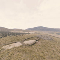
Description: Barpa Langass is the largest and best preserved of the Neolithic chambered burial cairns on North Uist. According to Erskine Beveridge its massive size suggests that it was the burial place of some great chief and was intended as both a tomb and a monument. Its prominent outline and siting, midway up Ben Langass, is remarkable for the labour which must have been involved in carrying and placing so many large stones over a great distance in order to form its pyramid shape. Beveridge found remnants of burnt burials and fragments of Bronze Age urn pottery within the first chamber and he suggested that two further chambers may well lie beyond the entrance to the east. It is now too dangerous to enter because of the collapsed stonework. Pobull Fhinn is the most conspicuous Megalithic stone circle on North Uist and lies on a plateau overlooking the sea an easy walk away from Barpa Langass. It is interesting to speculate on the type of social relationships that might have existed between the two sites. The stones of Pobull Fhinn are shaped in an oval rather than a circle, their east-west axis being slightly longer than that to the north-south. The purposes of such circles are still open to considerable debate - were they placed to plot the celestial movements of the sun, the seasonal cycles or those of the dark, the moon and the stars? What community celebrations or rituals might these huge stones have been hewn and dragged so high up to denote? Certainly they represent considerable effort and confidence on the part of the early Neolithic farming communities who erected them.
Leacach An Tigh Chloiche, North Uist
Leacach An Tigh Chloiche, North Uist
Description: Unival, a small, roughly-built, square passage grave lies on an elevated plateau on the hill of the same name, and, as Beveridge noted, carries the Gaelic name, ‘Leacach an Tigh Chloiche’, or ‘place of slabs of the stone house’. Excavated by Sir Lindsay Scott during the 1930s, it was found to house a small slab-built cist about 0.5 metres high, in which was the skeleton of a young woman, together with the rib-bones of a younger person, who may have been buried earlier. Ian Armit noted that it appeared that burning charcoal had been tipped onto the skeleton a long time after its burial, suggesting visits to the tomb for ritual purposes other than burial. Amongst the numerous finds of local pottery, discovered by Scott, the rarest was an almost complete Grooved Ware bowl and fragments of a beaker. These were common to later Neolithic finds across the mainland, suggesting the tomb continued to be used for burials well into the Bronze Age.
Longhouse Farming Settlement
Longhouse Farming Settlement
Lord of the Isles - 15th Century Finlaggan
Lord of the Isles - 15th Century Finlaggan
Description: Finlaggan, the centre of the Lordship of the Isles, an island settlement in the beautiful secluded Loch Finlaggan in the northeast corner of the Isle of Islay. Photospheres from a VR exhibit in the Finlaggan Visitor Centre.
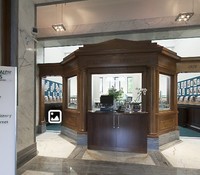
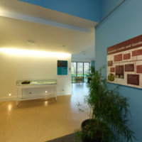
MUSA
MUSA
Description: University museum with 4 galleries exploring St. Andrews through the ages, with a sea-view terrace.
McManus Gallery, Dundee, Scotland
McManus Gallery, Dundee, Scotland
Description: The McManus: Dundee's Art Gallery and Museum is a Gothic Revival-style building, located in the centre of Dundee, Scotland. The building houses a museum and art gallery with a collection of fine and decorative art as well as a natural history collection. It is protected as a Category A listed building.
Moncreiffe Hill Fort Tay Landscape Partnerhip
Moncreiffe Hill Fort Tay Landscape Partnerhip
Description: Mountain ridge with forest trails featuring carved-wood outdoor sculptures & ancient hill forts.
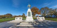
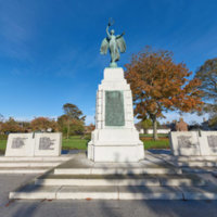
Montrose War Memorial
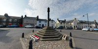
Montrose War Memorial
Description: At Hope Paton Park in Montrose is this granite memorial topped with a bronze statue of Peace. The central element is dedicated to WWI, with bronze plaques commemorating those who fought from Montrose. This is flanked by two blocks on each side which remember soldiers from WWII. Originally unveiled in 1922, the WWII blocks were added later. This tour is a 360º photograph taken in front of the monument allowing for full frontal views of all five elements. Accessibility note: The memorials are accessible from the pavement on the level.
Montrose War Memorial
Montrose War Memorial
Description: At Hope Paton Park in Montrose is this granite memorial topped with a bronze statue of Peace. The central element is dedicated to WWI, with bronze plaques commemorating those who fought from Montrose. This is flanked by two blocks on each side which remember soldiers from WWII. Originally unveiled in 1922, the WWII blocks were added later. This tour is a 360º photograph taken in front of the monument allowing for full frontal views of all five elements. Accessibility note: The memorials are accessible from the pavement on the level.
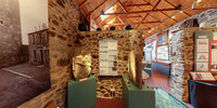
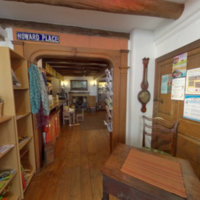
Museum of Abernethy
Museum of Abernethy
Description: The Museum of Abernethy was opened in May 2000 by Magnus Magnusson. The Museum has held the Visit Scotland four stars award since 2001. The building, which stands within the lands of the old Culdees monastery, dates from the eighteenth century. Originally consisting of a byre, stable and cattle rede, it was renovated during the 1990s to house the Museum. In keeping with the aim of preserving the building's heritage, some of the original features, such as the internal stone walls and an area of cobbled floor, have been left visible. Abernethy itself is a historic settlement having been occupied since Pictish times, and the aim of the Museum is to preserve as much as possible of this varied and extensive history.
Netherbow Port
Netherbow Port
Description: The Netherbow Port was a great gateway controlling access to Edinburgh from the Canongate (then a separate burgh). In May 1544 it was attacked by the English, who blew the gates open with a culverin (a type of cannon with a relatively long-range). The Netherbow was remodelled in the 1570s, and a central tower seems to have been added around this date. The gateway was eventually demolished in the mid-eighteenth-century as it was a hindrance to traffic.
Netherbow Port
Netherbow Port
Description: The Netherbow Port was a great gateway controlling access to Edinburgh from the Canongate (then a separate burgh). In May 1544 it was attacked by the English, who blew the gates open with a culverin (a type of cannon with a relatively long-range). The Netherbow was remodelled in the 1570s, and a central tower seems to have been added around this date. The gateway was eventually demolished in the mid-eighteenth-century as it was a hindrance to traffic.
Newhaven and Western Harbour
Newhaven and Western Harbour
Description: This is a primarily residential area of Edinburgh, seen here is a large development on the waterfront The tour shows a section of Leith Harbour, and the Western Harbour development, included within the 360º image is a drone flyby of the area too. Accessibility note: N/A
Paisley Abbey
Paisley Abbey
Description: Paisley Abbey is a parish church of the Church of Scotland on the east bank of the White Cart Water in the centre of the town of Paisley, Renfrewshire, about 12 miles west of Glasgow, in Scotland. Its origins date from the 12th century, based on a former Cluniac monastery.
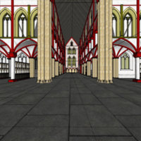
Perth 1440
Perth 1440
Description: Perth is a city in central Scotland, on the banks of the River Tay. It is the administrative centre of Perth and Kinross council area and the historic county town of Perthshire.
Perth 1440
Perth 1440
Description: A project with Tayside Landscape Partnership. VR reconstruction of Perth, Scotland in 1440.
Perth Museum
Perth Museum
Description: The exhibition - a collaboration between Culture Perth and Kinross, the University of St Andrews Open Virtual Worlds Research team, Perth and Kinross Heritage Trust, and Tay Landscape Partnership with support from the Heritage Lottery Fund.
Pictish Rhynie Landscape
Pictish Rhynie Landscape
Description: A landscape rich in history.
Port of Leith
Port of Leith
Description: The Firth of Forth is a centre of commerce in Edinburgh and shown here are five different points along the coast line. This tour consists of a set of 360º images including information points and embedded videos. Accessibility note: N/A
Port of Leith
Port of Leith
Description: The Firth of Forth is a centre of commerce in Edinburgh and shown here are five different points along the coast line. This tour consists of a set of 360º images including information points and embedded videos. Accessibility note: N/A
Portencross Castle
Portencross Castle
Description: Portencross Castle is a wonderful example of what can be achieved when everyone involved in a project works together to overcome problems. http://www.portencrosscastle.org.uk/
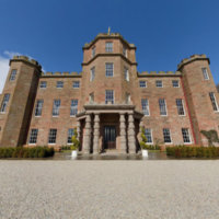
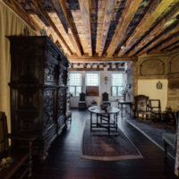
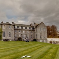
Raemoir House
Raemoir House
Description: Raemoir House is a private Mansion House surrounded by 14 acres of parkland. The buildings date back to 1715 and contains a multitude of rooms like the Oval dining room and the Big Fish bar, named after the 96 lbs fish hanging over the whiskey cabinet. The video tour above has an audio guide to go with some 360º photography of the building. Linked below that is an interactive tour, found through the link and at the bottom of their homepage, which consists of an set of 360º images. Acessibility note: Accessible parking is available.
Rockcliffe (National Trust for Scotland)
Rockcliffe (National Trust for Scotland)
Description: Rockcliffe is one of Scotland's most beautiful coastlines, stretching along the Solway Firth on the southern edge of Dumfries and Galloway. Part of a National Scenic Area, this National Trust for Scotland nature reserve is fringed with wildflowers and dotted with sailing villages.
Rosemarkie
Rosemarkie
Description: Rosemarkie is a village on the south coast of the Black Isle peninsula in Ross-shire, northern Scotland
Rosslyn Chapel
Rosslyn Chapel
Description: Intricately carved chapel built in 1446, featured in The Da Vinci Code movie, with history talks.
Rowallan Castle
Rowallan Castle
Description: Rowallan Castle is steeped in history, with its original structure believed to date back to the 13th century.
Scapa Flow
Scapa Flow
Description: Scapa flow exhibition showing history during the First and Second World Wars
Scone Abbey
Scone Abbey
Description: The precise location of Scone Abbey had long remained a mystery, but in July 2007 archaeologists pinpointed the location using Ground Penetrating Radar (GPR) technology, the Abbey’s structure was revealed to be larger than first imagined.
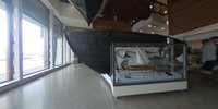
Shetland Museum Boat Hall
Shetland Museum Boat Hall
Description: The New Shetland Museum and Archives at Hay's Dock, Lerwick, Shetland, Scotland, was officially opened on 31 May 2007 by HM Queen Sonja of Norway and the Duke & Duchess of Rothesay.
St Andrews 1559
St Andrews 1559
Description: This phase of the project has been funded by St Andrews University Research Impact. impact.wp.st-andrews.ac.uk/ More information here: 2017.wp.st-andrews.ac.uk/2017/04/10/reconstructing-pre-reformation-st-andrews/
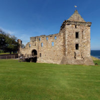
St Andrews Castle
St Andrews Castle
Description: This castle dates from the 13th century and was built on a northern headland of St Andrews. Now in ruins, the castle still partially watches over the seas and surrounding area of the town. The famous ‘bottle dungeon’ is found here, cut out of the stone beneath the fortress. Visitors can compare the underground siege mine and the decorative Hamilton Facade. This tour consists of multiple 360º images in and around the ruins. Accessibility note: There is a wheelchair accessible visitor centre which includes multi-sensory elements for those with visual impairments. The dungeon, mines, and upper floors of the castle are not accessible for those with mobility issues or wheelchairs.
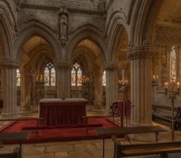
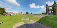
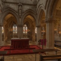
St Andrews Cathedral
St Andrews Cathedral
Description: The ruined Roman Catholic cathedral was built 1158 and was the main seat of the Catholic Church in Scotland in the Middle Ages. The cathedral fell into disuse after the Scottish Reformation in the sixteenth century, which outlawed Catholic mass. The building was stormed by Protestants, destroying the interior, and the ruins were used for building material for the town. The ruins of the cathedral suggest that the building was once 119 metres tall, making it the largest church to have been built in Scotland. The tour consists of ten 360º views of the cathedral which can be clicked between in thumbnails on the bottom of the page or in icons spread around the images. Accessibility note: All areas of the cathedral, visitor centre, shop, and museum are accessed over grass or gravel paths. A ramp is available for entry to the museum.
St Andrews Preservation Trust
St Andrews Preservation Trust
Description: Welcome to the tour of St Andrews Preservation Trust musuem. Here you will be able to explore the museum, enjoy reconstructions of past life in St Andrews and relax in its gardens!
St Andrews University - School of Classics
St Andrews University - School of Classics
Description: St Andrews University was founded between 1410 and 1413, and is the oldest of the four ancient universities of Scotland and the third oldest university in the English-speaking world. The university consists of a main campus and owns modern and historic buildings throughout the town. The university has over 10,000 students admitted. The tour consists of two 360º images of the front of the building. Accessibility note: Accessibility levels vary across campus.
St Giles Kirk
St Giles Kirk
Description: St Giles’ was the most important church in the burgh of Edinburgh (although it was not a cathedral until the 1630s). In 1544 St Giles’ was still a Catholic Church. It was lavishly decorated with statues and stained glass, and housed the altars of the local craft guilds. The feast day of St Giles (on 1st September) was marked by a religious procession along the Royal Mile. In 1558 Protestant Reformers disrupted the religious festivities, throwing a statue of St Giles to the ground, and smashing it upon the paving stones. Two years later Scotland officially rejected Catholicism, and St Giles’ became a Protestant place of worship.
St Maurs, Glencairn Parish Church
St Maurs, Glencairn Parish Church
Description: The church at Kilmaurs was in the possession of Kelso Abbey as early as 1170. In 1413 the present foundation was endowed by Sir William Cunninghame as a collegiate church. Rebuilt by Robert S Ingram 1888 in a cruciform shape. Stained glass, 20th-century, including a window by Roland Mitton of Livingston, and three rose windows. The clock tower holds the original bell inscribed ‘Michael Burgerhuys Me Fecit 1618’. Glencairn Aisle adjacent to the church with sculptured mural 1600 commissioned by James 7th Earl of Glencairn, in memory of the Earl and Countess of Glencairn, and worked by David Scougal, mason and burgess.
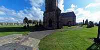
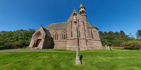
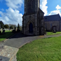
St Palladius Church
St Palladius Church
Description: Constructed in 1885, the church was built as an estate chapel for the owner of Drumtochty Castle, the Rev. J. S. Gammell. The building was commissioned from the architectural firm Pirie and Clyne, the Neo-Gothic design features an aisle-less nave with a semi-circular chancel featuring narrow stained glass windows. The south transept holds an exterior statue of St Palladius. Attached to the transept is a pencil stair tower with a gallery at the top. The church serves as an Episcopal church and is still in use and is open for worship. 360º photograph of the church's South facing exterior and cemetery. Accessibility note: A gravel road leads through the gates and up to the entry to the church. No path leads around the building. There are three stone steps at the main entrance.
St Palladius Church
St Palladius Church
Description: Constructed in 1885, the church was built as an estate chapel for the owner of Drumtochty Castle, the Rev. J. S. Gammell. The building was commissioned from the architectural firm Pirie and Clyne, the Neo-Gothic design features an aisle-less nave with a semi-circular chancel featuring narrow stained glass windows. The south transept holds an exterior statue of St Palladius. Attached to the transept is a pencil stair tower with a gallery at the top. The church serves as an Episcopal church and is still in use and is open for worship. 360º photograph of the church’s South facing exterior and cemetery. Accessibility note: A gravel road leads through the gates and up to the entry to the church. No path leads around the building. There are three stone steps at the main entrance.
St Salvator's Chapel
St Salvator's Chapel
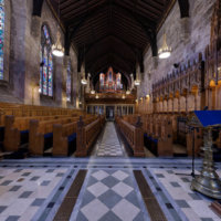
Description: This chapel was founded in 1450 and built in a neo-Gothic style. It was originally founded with a missionary and educational function as it was part of Bishop Kennedy’s College of the Holy Saviour. St Salvator’s has been the site of much conflict between Protestants and Catholics, with both taking their toll on the building. There has been restoration and changes made in the 18th, 19th, and 20th centuries and the current building is a mixture of old and new, showing signs of its difficult history. This tour consists of a 360º photograph of the inside of the chapel. Accessibility note: The northern entrance is wheelchair accessible.
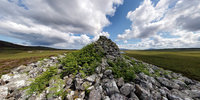
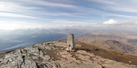
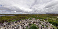
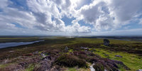
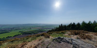
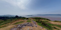
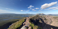
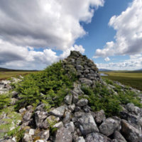
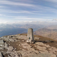
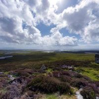
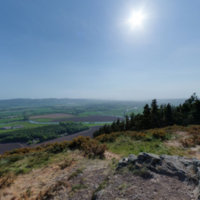
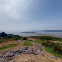
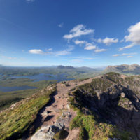
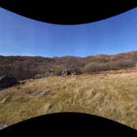
Stac Pollaidh
Stac Pollaidh
Description: View from summit of Stac Pollaidh
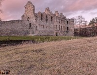
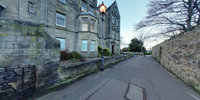
Sunnyside Royal Hospital
Sunnyside Royal Hospital
Description: Founded in 1781 by Susan Carnegie, it was originally called the Montrose Lunatic Asylum, Infirmary, and Dispensary. It was brought under NHS control in 1948, and in 1962 it became the Sunnyside Royal Hospital. The hospital closed in 2011 but the building still stands. The tour is a 360º photograph from the outside of the abandoned hospital Accessibility note: The hospital itself is not open to the public, but the grounds around it are fairly uneven and grassy.
Sunnyside Royal Hospital
Sunnyside Royal Hospital
Description: Founded in 1781 by Susan Carnegie, it was originally called the Montrose Lunatic Asylum, Infirmary, and Dispensary. It was brought under NHS control in 1948, and in 1962 it became the Sunnyside Royal Hospital. The hospital closed in 2011 but the building still stands. The tour is a 360º photograph from the outside of the abandoned hospital Accessibility note: The hospital itself is not open to the public, but the grounds around it are fairly uneven and grassy.
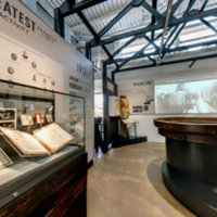
Surgeons' Hall Museums Virtual Tour
Surgeons' Hall Museums Virtual Tour
Description: A classical 1832 building houses 18th century anatomy specimens and visiting medical exhibitions.
Taigh Chearsabhagh
Taigh Chearsabhagh
Description: Taigh Chearsabhagh Museum & Arts Centre is a hub for people to meet, share ideas, learn new skills and experience exhibitions and events that are imaginative and stimulating.
Taigh Chearsabhagh Museum and Arts Centre
Taigh Chearsabhagh Museum and Arts Centre
Description: The Centre was founded in 1993 by Comann Eachdraidh Uibhist a Tuath and the Uist Art Association and the museum explores North Uist’s social, domestic, economic, cultural and religious life. The collection is built up from artefacts from the nineteenth and twentieth century, as well as a collection of Scottish, local, and international art and craft pieces. Taigh Chearsabhagh Museum & Arts Centre is located on the shoreline of a marine Special Area of Conservation. The tour consists of two 360º images taken inside two rooms of the Centre that can be moved between. Accessibility note: The centre is wheelchair accessible.
Tentsmuir Forest and Beach
Tentsmuir Forest and Beach
Description: Tentsmuir Forest and Tentsmuir National Nature Reserve are in north east Fife, Scotland. Covering some 50 square miles, the forest was originally sand dunes and moorland before acquisition by the Forestry Commission in the 1920s.
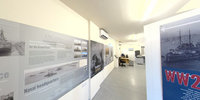
The Devils Porridge WW Gallery
The Devils Porridge WW Gallery
Description: Our new state-of-the-art museum has something for everyone. Experience life in a World War One Trench and explore the Factory to discover what life was like for the thousands of munitions girls who flocked to work here.
The Gordon Highlanders Museum 360 Virtual Tour - Aerial
The Gordon Highlanders Museum 360 Virtual Tour - Aerial
Description: The only Visit Scotland 5-Star Attraction in Aberdeen, the museum tells the extraordinary 200 year story of “the Finest Regiment in the World!”* Situated in the fashionable west end of Aberdeen, Scotland, in the former home of leading Scot
The Highlanders Museum
The Highlanders Museum
Description: The Highlanders Museum World War II Exhibition
The Hill House
The Hill House
Description: In 1904 this building was made for the publisher Walter Blackie by Charles Rennie Mackintosh and Margaret Macdonald Mackintosh. The entire house, inside and out, was designed by Mackintosh including furniture and fittings. He even recommended what sort of decorations the residents should use, such as flowers. The building has some structural issues and a large rejuvenation project is being undertaken (2019) in order to increase its longevity. The tour consists of a set of 360º images of the interior of the house with information points on various items. Accessibility note: There is accessible parking, wheelchair access, a hearing loop, and braille notices.
The Kelpies
The Kelpies
Description: The Kelpies are two 30-metres tall sculptures depicting the heads of two kelpies, mythological water spirits. The sculptures were made by Andy Scott and completed in 2013. The Kelpies are the largest equine sculptures in the world and represent the history of horse powered heritage across Scotland. The Kelpies are located inside the Helix Community Park, next to an extension of the Forth and Clyde Canal. The tour is a 360º photo that shows the area. Accessibility note: The area is accessible throughout for wheelchair users.
The Kelpies
The Kelpies
Description: The Kelpies are two 30-metres tall sculptures depicting the heads of two kelpies, mythological water spirits. The sculptures were made by Andy Scott and completed in 2013. The Kelpies are the largest equine sculptures in the world and represent the history of horse powered heritage across Scotland. The Kelpies are located inside the Helix Community Park, next to an extension of the Forth and Clyde Canal. The tour is a 360º photo that shows the area. Accessibility note: The area is accessible throughout for wheelchair users.
TimeSpan Museum
TimeSpan Museum
Description: Timespan is a cultural organisation in Helmsdale, Sutherland in the Far North of Scotland. It offers a high quality venue with a museum, contemporary art gallery, archive, shop and cafe. Established in 1986, Timespan has developed from a community heritage enterprise to a multi-award-winning creative development hub. Timespan provides a rich cultural programme of events and activities to its visitors every year. The organisation will contribute to CINE with a case study and best practice guidelines based on research of the nearby Strath of Kildonan.
Tomintoul History
Tomintoul History
Description: Founded by the Duke of Gordon in 1776, Tomintoul is situated on the line of the old military road built following the 1745 Jacobite rebellion. The Duke hoped that the production of linen would provide an industry for local people
Torridon
Torridon
Description: With some of the most spectacular mountain scenery in Scotland, Torridon is a magnet for walkers, geologists and naturalists. The estate includes some of Scotland's finest mountain scenery, comprising Liathach, 1,054m (3,456ft) which has seven tops and Beinn Alligin, 985m (3,230ft), composed mainly of Torridonian sandstone dating back 750 million years. Routes to the high tops, and others along the coast, are detailed at the Countryside Centre. You’ll also find information about the wildlife on the estate, part of which is in the Beinn Eighe National Nature Reserve.
Trinity College
Trinity College
Description: Trinity College and Hospital was founded by Mary of Gueldres (wife of James II) in the mid-fifteenth century. It functioned both as a community of priests and a shelter for the poor and sick of Edinburgh. The church was meant to be a large Gothic building, but only the choir and transepts were ever completed. The famous Trinity altarpiece by Hugo van der Goes is probably from this church. The Hospital survived the Reformation, but was demolished in the nineteenth century to make way for Waverley Station. Fragments of the church building were reconstructed on a new site as Trinity Apse.
Udal
Udal
Description: Iain Crawford, a passionate archaeologist and ethnographer who was influenced by the writings of Erskine Beveridge, decided to concentrate his searches in the 1960s on sites that might have been continuously inhabited over a very long period and yet remained visible. He wanted to get a clearer picture of daily life and work from the Mesolithic, through to the Bronze and Iron Ages, onwards as close to the present day as possible. The two main sandhills at Udal, North and South, gradually provided him with settlement remains which represent the rarity and importance of this site. The Udal South Mound revealed evidence of two stone built round houses or 'wheelhouses', now extremely vulnerable to the elements. Pottery shards, stone tools and some bronze and metal items, held by Glasgow University, show evidence of habitation from the Late Bronze Age through to the Late Iron Age. The Udal North Mound takes the period of settlement up to Viking and Mediaeval times and the finds include jewellery and a Norse gold coin of Harald Hardrada. There is evidence of continuous settlement through to the 19th century and much more exciting excavation remains to be researched by the Udal project on this site of major historical significance.
Unival
Unival
Description: Unival is a small, roughly-built square passage grave that lies on an elevated plateau on the hill of the same name. As Erskine Beveridge noted, it carries the Gaelic name ‘Leacach an Tigh Chloiche’ or ‘place of slabs of the stone house’. Excavated by Sir Lindsay Scott during the 1930s, it was found to house a small slab-built cist about 2ft high which contained the skeleton of a young woman, together with the rib-bones of a younger person who may have been buried earlier. Ian Armit noted that it appeared that burning charcoal had been tipped onto the skeleton a long time after its burial, suggesting visits to the tomb for ritual purposes other than burial. Amongst the numerous finds of local pottery discovered by Scott, the rarest was an almost complete Grooved Ware bowl and fragments of a beaker. These were common to later Neolithic finds across the mainland, suggesting the tomb continued to be used for burials well into the Bronze Age.
University of Edinburgh
University of Edinburgh
Description: Founded in 1582, the University of Edinburgh is ranked in the top 20 universities in the world (2019). The University hosts over 35,000 students across multiple campuses in the city. This tour provides an insight into the old and new of the university with a set of 360º images showing the Old Campus Courtyard, the Informatics Forum, and the McEwan Hall Accessibility note: Accessibility levels vary across the campus.
Univirsity of Dundee
Univirsity of Dundee
Description: The University of Dundee was founded in 1881 as a constituent college of the University of St Andrews before gaining independent university status in 1967. The university has 17,000 students and the main teaching facilities are located in the West End of Dundee. The tour consists of a aerial map with the buildings belonging to Dundee University marked out by pop-up menus. Hovering over the menu provides information on what building it is and reveals an ‘Explore’ button. Clicking this takes you inside the building with an option to click between 360º photographs of rooms inside the buildings, listed in a menu in the lower left corner. Accessibility note: accessibility levels vary across the campus.
Urquhart Castle
Urquhart Castle
Description: The present ruins of Urquhart Castle stem from the thirteenth to the sixteenth centuries but there are traces of a Medieval fortification on the site stemming from the seventh century. The castle is one of the largest in area in Scotland. It has belonged to many different clans but most notably belonged to the Grants and was under siege by Jacobites following the 1688 Revolution. The tour starts with a view over that castle and has arrows that are used to navigate through the landscape. The tour can be viewed in Virtual Reality. Accessibility note: The visitor centre is fully accessible and there is a photographic guide for those who have mobility issues. Disability buggies are available on request and accessible parking spots.
Virtual Medieval Abernethy 1070AD
Virtual Medieval Abernethy 1070AD
Description: Abernethy is a village in Perth and Kinross, Scotland, situated 8 mi south-east of Perth. It has one of Scotland's two surviving Irish-style round towers. The round tower is approx. 22 metres high and has an internal diameter of 2.515 metres. The exterior diameter is 4.648 metres near the base, and 4.267 metres at the top. Today there is a Pictish carved stone at the base of the tower, but this is not the stone’s original location. (The stone was dug out of the foundations of a local house. The tower is thought to date from the eleventh century, but may incorporate the foundations of an earlier structure. The round tower is thought to relate to a Culdee monastery. We are not sure at what date the monastery was founded. [Source: https://canmore.org.uk/site/27914/abernethy-round-tower]
Virtual Moredun Top Hillfort 50AD
Virtual Moredun Top Hillfort 50AD
Description: Moredun Top Hillfort located on Moncreiffe Hill near Perth, Scotland. The site of an Iron Age fort. For more information: http://www.taylp.org/archaeology-projects/hillforts-seats-of-power/
Virtual St Kilda 1890
Virtual St Kilda 1890
Description: Take a tour! Recreating the Village Bay of St Kilda as it would have looked, enables a better understanding of how the island was and the way of life, around 1890. before the island was evacuated on 29 August 1930.
Virtual tours of MV Spartan and SY Carola
Virtual tours of MV Spartan and SY Carola
Description: As a part of our project “Scanning The Horizon” we have created virtual tours to improve access to our collection. Thanks to 360° photography you can now enjoy tours of our vessels from the comfort of your own home! Move between panoramas to explore different sections of the two vessels and gain access to areas usually “off-limits”. If you own a VR headset you can view our tours in the VR mode. While wearing the headset, launch this website in Firefox Reality and click on the VR goggles symbol. Enjoy!
Wallace's Monument, Ayrshire
Wallace's Monument, Ayrshire
Description: This category A listed building is a dramatic, Neo-Gothic tower was built to commemorate William Wallace between 1855-57 after designs by Robert Snodgrass Its square-plan footprint castellated top give it a powerful sense of rootedness in the landscape it sits in, emulating the strength of the man it was built for The name Barnweil was said to have originated from a comment Wallace made that the Barns of Ayr burned well when full of English soldiers. However, it is actually derived from its location near the ruins of the medieval church of Barnweil, whos parish was suppressed in the 17th century There is a 360º, black and white, image of the monument from the field in which it stands Accessibility note: Access to the monument is only possible by a climbing the hill which it caps
Wallace's Monument, Ayrshire
Wallace's Monument, Ayrshire
Description: This category A listed building is a dramatic, Neo-Gothic tower was built to commemorate William Wallace between 1855-57 after designs by Robert Snodgrass Its square-plan footprint castellated top give it a powerful sense of rootedness in the landscape it sits in, emulating the strength of the man it was built for The name Barnweil was said to have originated from a comment Wallace made that the Barns of Ayr burned well when full of English soldiers. However, it is actually derived from its location near the ruins of the medieval church of Barnweil, whos parish was suppressed in the 17th century There is a 360º, black and white, image of the monument from the field in which it stands Accessibility note: Access to the monument is only possible by a climbing the hill which it caps
West Bow
West Bow
Description: The West Bow was a steep z-shaped street which formed the main route between the Royal Mile and the Grassmarket. The narrow road was shadowed by buildings with projecting galleries and overhanging upper storeys. By the early nineteenth-century the properties in the West Bow had fallen on hard times, and in 1829 it was remarked that ‘few will regret their removal, to make room for modern improvements’. Only a few years later much of the West Bow was demolished to make way for the newly created Victoria Street.